
Petroglyph left behind by one of the early emigrants. And my trusty steed of the time. Look, 26” Wheels!
“January 18, 2022
"Black Rock Field Office announces the annual temporary closure of the High Rock Canyon Road"
WINNEMUCCA, NV – The Black Rock Field Office, Winnemucca District, Bureau of Land Management, will be seasonally closing a portion of the High Rock Canyon Road to vehicle use beginning Monday, February 7, through Friday, May 6, 2022.”
For most of this time of year, the canyon is super wet, and possibly under snow.
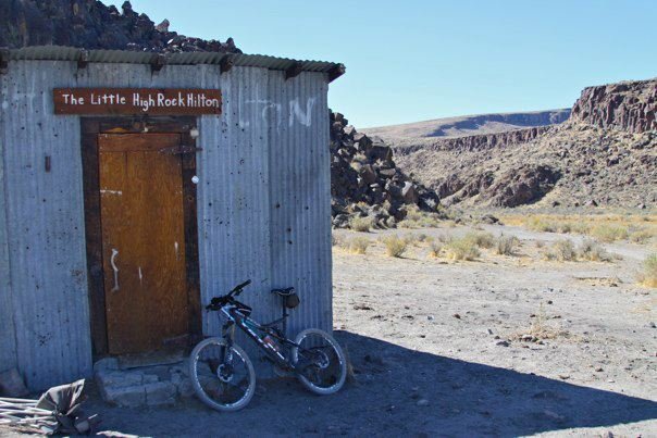
5 Star! Little High Rock Hilton at the mouth of Little High Rock Canyon.

This is the entrance to High Rock Canyon
The Lassen Applegate Trail was one of the first trails that Emigrants used to cross into California and Oregon for the Gold Rush in the mid and late 1850’s . Black Rock Canyon is part of the Lassen Applegate Trail. There are two ways to get to the Black Rock Canon, and this is the easiest way. Both access points start at Gerlach, Nv, and head north. Past Gerlach, you can continue North up the West side of The Black Rock Desert to Soldier Meadows. Soldier Meadows has since turned into a B&B with amazing natural hot springs, but many times a 4 wheel drive is necessary to get there. This ride will give you the easier route to get to High Rock Canyon. I have ridden this ride twice. Once on a 26” wheel Mountain Bike, and once on a Felt Gravel Bike. If you attempt this ride in the middle of summer, a mountain bike might be easier because it can get sandy. Or make sure your Gravel Bike can take wider tires, something like a 40mm or wider.
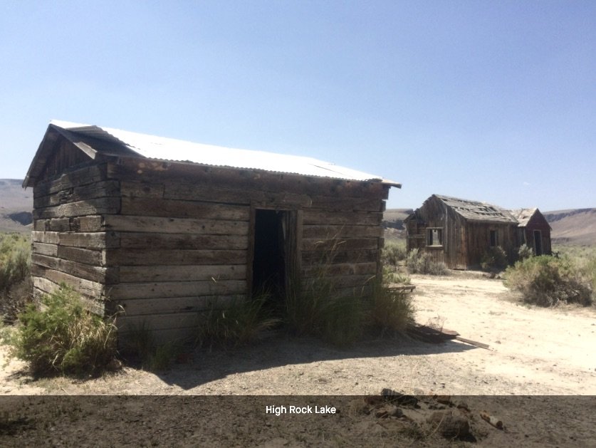
I believe the closer cabin was the bar, and the further away cabin was the “Hotel” at High Rock Lake.
The start of this historic ride is 166 miles from Reno, so it is a drive. If you like/love the desert, it is a beautiful trip. From Reno, take I-80 East to Wadsworth, and take Hwy 447 North to Gerlach. Gerlach is your last stop for any amenities, and a great stop at Bruno’s for breakfast, lunch or dinner. Call ahead to make sure they are open. There is also a gas station here. Just out of Gerlach, take a right at the “Y” on Hwy 34 towards Vya. Continue on Hwy 34 for 41 miles to the start of the ride. At some point on Hwy 34 it does turn to dirt, but it is a beautiful road to travel. At 41 miles from Gerlach, you will see a BLM “Black Rock Desert Wilderness” information sign on the right. There is a map on the sign and this is your start point. The road is a decent road, we did the ride on Gravel bikes with 700x32mm tires, but a slightly wider tire, 47’s would be better. The road if fairly good, but gets sandy in sections, and a wider tire would give you more control. As well, this ride is better done in the spring, late spring, or fall. During the heat of the summer, the sand will be difficult to cross, and it gets hot. The road starts out relatively flat for 3 miles, then descends to the valley floor. Once on the valley floor you will start to run into sandy sections, follow the road north, and in 11.4 miles from the car you will arrive at “Little High Rock Hilton!” Really just a shack at the mouth of Little High Rock Canyon, which is also a Wilderness Area. Jump on your bike and walk around. It is a beautiful canyon with Little High Rock Creek ever so slowly draining into High Rock Lake to the North and East of Little High Rock Canyon. Jump back on the bike and head North for 13.1 miles from the car. You will see High Rock Lake to your right, and a jeep road that heads right towards the dry lake. Take this right, and weave through the 6 and 7 ft high sagebrush for about a mile, and you will run into the old Hotel and Bar that was a stopping point for the wagon trains heading to California and Oregon. The 2 buildings would not hold more than possibly 4 people, but it was a stopping point. If you walk around, especially to the east just a bit, I found old rusted Hay Bailing equipment, which would mean that in the mid to late 1800’s, they were farming hay for the emigrants. Last time I was at High Rock Lake, there was still standing water in the far South East corner of the lake. From the cabins, follow the road to the North, and in about another mile you will take a left on the jeep road. If you were to go right, you would go downhill, paralleling Fly Creek on your right, and drop out at Soldier Meadows. That would be the other way to get here. At this point, take a right and the road will start up the mouth of the canyon in front of you. This is High Rock Canyon. Not much to see, and you wonder why it is called High Rock Canyon? As you continue West up High Rock Canyon, in about 2 miles, all of the sudden you will see huge, breathtaking rock walls towering up 800 ft. from the valley floor. One more mile up the canyon you will see a clearing on the right, and if you walk up to the cliff face you will see a petroglyph (rock carving) with the following engraved, “George N Jaquith July the 16th 1852 From Wis.” The Lassen Applegate Trail started in 1849, but the first European men to discover the route were John C. Fremont and Kit Carson in 1843. Another mile West up the road, stay to the right. Left is a meadow that is fed by Mahogany Creek. The road goes into a box canyon and stops. So continue strait West up the road, and you will be traveling over some basalt rock. The grooves in the basalt rock were ground down by Wagon Wheels. If you watch the video, you can see the wagon wheel tracks in the rock. 1/ mile up the canyon, you will come to High Rock Gorge. Here the rocks are still about 800 ft off the valley floor, and is just spectacular. Once through the gorge, you open into a large opening, and from here West, the road just meanders through more of High Rock Canyon, but not as spectacular as the lower section. 14 miles up the trail is Steven’s Camp, or Recreation Area. It is a first come, first serve cabin with some amenities. It would make an amazing overnight gravel ride to Steven’s camp, then home the next day. Here is the BLM link to Steven’s Camp. No matter how far you want to go, at what ever point, retrace your steps back to the car. The other option is to drive further towards High Rock Lake. Remember that in summer, it can get super sandy, so multiple vehicles and 4wd would be best. If solo, you can always easily drive in from Hwy 34 five ish miles then park and ride from there. That would save you 10 miles round trip so you could explore High Rock Canyon more. Last thing to note, you will truly be in the middle of nowhere. Please be prepared for anything. You will be a long way from any help from anywhere.

High Rock Gorge


WHEN ACCESSING THE RIDE WITH GPS LINK BELOW, THERE IS A DROP DOWN MENU ON THE UPPER RIGHT OF THE MAP. THIS DROP DOWN MENU ALLOWS YOU TO CHANGE THE KIND OF MAP YOU ARE LOOKING AT, FROM A GOOGLE SATELLITE MAP TO A USGS TOPO MAP, AND ANY OTHER MAP IN BETWEEN. IF YOU WOULD LIKE THE GPS FILE FOR YOUR GARMIN, FEEL FREE TO E-MAIL OR CALL THE SHOP.